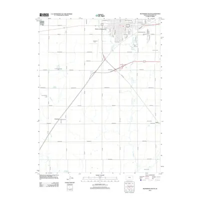
2012 Map of McPherson South
USGS Topo · Published 2012About this map
The agricultural and energy landscapes of central Kansas converge south of McPherson, where a dense grid of section roads like Kiowa Rd and Chisholm Rd organizes the prairie. Educational institutions anchor the northern edge of the sheet, notably McPherson Coll and the Central Christian Coll Of Kansas, providing a collegiate character to the outskirts of the city. To the south and west, the smaller settlements of Groveland and Elyria remain as quiet residential nodes amidst an active industrial landscape defined by numerous petroleum resources, including the Groveland Northeast Oil Field and the Voshell Oil Field. The terrain is drained by several meandering waterways such as Blaze Fork and Dry Turkey Cr, which flow toward Lake Inman at the southern boundary. This proximity of higher education, local aviation at the Mc Pherson Airport, and extensive oil production illustrates the multifaceted economic identity of the region.
Find a feature on this map
63 named features on this map. Tap any name to fly to it.
Don’t see what you’re looking for? This feature index may not catch every label — zoom into the map to look around manually.
Map Details
Editions of this 2012 McPherson South Map
This is the sole edition of this map. No revisions or reprints were ever made.
Other maps of this area

1891 · Hutchinson
USGS Topo · 1:125,000

1893 · Hutchinson
USGS Topo · 1:125,000

1955 · Hutchinson
USGS Topo · 1:250,000

1959 · Hutchinson
USGS Topo · 1:250,000

1964 · Conway
USGS Topo · 1:24,000

1965 · Mc Pherson South
USGS Topo · 1:24,000

1965 · Galva
USGS Topo · 1:24,000

1965 · Halstead NW
USGS Topo · 1:24,000
1965 · Mc Pherson SE
USGS Topo · 1:24,000
1965 · Mc Pherson North
USGS Topo · 1:24,000