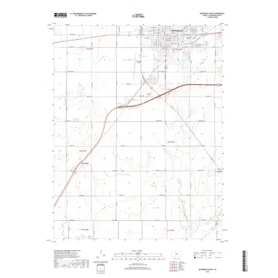
2018 Map of McPherson South
USGS Topo · Published 2018About this map
McPherson serves as the primary hub of this landscape, its residential grid and industrial areas tapering south into the agricultural plains of central Kansas. The geography is defined by a network of creeks and drainage forks, including Bull Creek and the meandering path of Dry Turkey Creek, which cut through the township sections. Small rural clusters at Groveland and Elyria represent the satellite settlements that support the regional farming economy. In the northern reaches, civic life is reflected in the layout of Lakeside Park and Centennial Lake Paths and the McPherson Cemetery. The map also preserves the paths of several significant rural corridors, such as Chisholm Road and Cimarron Road, which follow the long-established section lines of the Public Land Survey System, illustrating the persistent 19th-century grid imposed upon the prairie.
Find a feature on this map
38 named features on this map. Tap any name to fly to it.
Don’t see what you’re looking for? This feature index may not catch every label — zoom into the map to look around manually.
Map Details
Editions of this 2018 McPherson South Map
This is the sole edition of this map. No revisions or reprints were ever made.
Other maps of this area

1891 · Hutchinson
USGS Topo · 1:125,000

1893 · Hutchinson
USGS Topo · 1:125,000

1955 · Hutchinson
USGS Topo · 1:250,000

1959 · Hutchinson
USGS Topo · 1:250,000

1964 · Conway
USGS Topo · 1:24,000

1965 · Mc Pherson South
USGS Topo · 1:24,000

1965 · Galva
USGS Topo · 1:24,000

1965 · Halstead NW
USGS Topo · 1:24,000
1965 · Mc Pherson SE
USGS Topo · 1:24,000
1965 · Mc Pherson North
USGS Topo · 1:24,000