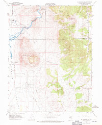
1968 Map of McTarnahan Hill
USGS Topo · Published 1971About this map
Prison Hill and the Carson River dominate this landscape on the boundary between Carson City and Douglas County. In the late 1960s, the area was defined by a mix of institutional land use and industrial extraction, most notably the Nevada State Medium Security Prison situated just west of the river. The presence of Washoe Indian Allotments indicates complex land ownership patterns that persisted through the mid-20th century, alongside active resource sites like the Bunker Hill Mine and various gravel pits. The Carson Valley floor shows the early footprints of regional infrastructure, including the Douglas County Airport and Sunrise Pass Road. Evidence of earlier eras remains via the McTarnahan Bridge (Site), while the thermal waters of Saratoga Hot Spring and hydraulic controls like the Mexican Dam reflect the valley's long history of water management.
Find a feature on this map
25 named features on this map. Tap any name to fly to it.
Don’t see what you’re looking for? This feature index may not catch every label — zoom into the map to look around manually.
Map Details
Editions of this 1968 McTarnahan Hill Map
4 editions found
Other maps of this area

1889 · Markleeville
USGS Topo · 1:125,000

1891 · Carson
USGS Topo · 1:125,000

1891 · Markleeville
USGS Topo · 1:125,000

1893 · Carson
USGS Topo · 1:125,000

1893 · Markleeville
USGS Topo · 1:125,000

1948 · Walker Lake
USGS Topo · 1:250,000

1956 · Freel Peak
USGS Topo · 1:62,500

1956 · Dayton
USGS Topo · 1:62,500

1956 · Carson City
USGS Topo · 1:62,500

1957 · Walker Lake
USGS Topo · 1:250,000