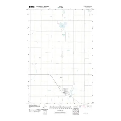
2011 Map of McVille
USGS Topo · Published 2011About this map
McVille anchors this Nelson County landscape, appearing as a organized grid of streets including N Main St, Golf Ave, and E Felton Ave. The surrounding terrain is defined by a series of significant water bodies and drainage features, most notably Olsen Slough, Berkland Slough, and Dahl Slough to the north, while Silver Creek and the McVille Coulee wind through the southern sections. Local infrastructure is well-marked, from the McVille Municipal Airport north of town to the McVille Railroad Dam situated along the coulee. For those researching family history in the area, the map precisely locates both the McVille Cemetery near the town center and the Hamlin Cemetery situated further west. This 2011 survey reflects the intersection of agricultural transport and water management in the North Dakota plains, showing a high-density grid of county roads and highways like HWY 15.
Find a feature on this map
37 named features on this map. Tap any name to fly to it.
Don’t see what you’re looking for? This feature index may not catch every label — zoom into the map to look around manually.
Map Details
Editions of this 2011 McVille Map
This is the sole edition of this map. No revisions or reprints were ever made.
Other maps of this area

1930 · Pekin
USGS Topo · 1:62,500

1942 · McVille
USGS Topo · 1:62,500

1951 · Pekin NE
USGS Topo · 1:24,000

1951 · Pekin
USGS Topo · 1:24,000

1951 · Pekin
USGS Topo · 1:62,500

1952 · New Rockford
USGS Topo · 1:250,000

1956 · New Rockford
USGS Topo · 1:250,000

1961 · Kloten NW
USGS Topo · 1:24,000

1961 · Binford NE
USGS Topo · 1:24,000
1961 · McVille
USGS Topo · 1:24,000