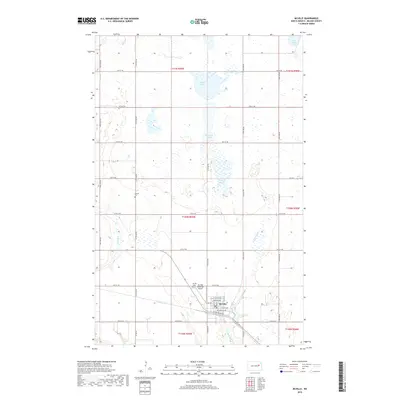
2018 Map of McVille
USGS Topo · Published 2018About this map
McVille anchors the southeast corner of this Nelson County landscape, where the grid of early twentieth-century street names like Nyhus Ave and Berwick Ave meets the open prairie. The surrounding terrain is defined by a series of significant depressions and water bodies, including Olsen Slough, Berkland Slough, and Dahl Slough, reflecting the region's post-glacial drainage patterns. For local historians, the map provides precise locations for the Hamlin Cem to the northwest and the McVille Cem just outside the town limits, near the Mc Ville Municipal Airport. Waterways such as Silver Cr and the McVille Coulee wind through the township sections, illustrating the natural water management systems that influenced the placement of roads and homesteads across this North Dakota farming territory.
Find a feature on this map
41 named features on this map. Tap any name to fly to it.
Don’t see what you’re looking for? This feature index may not catch every label — zoom into the map to look around manually.
Map Details
Editions of this 2018 McVille Map
This is the sole edition of this map. No revisions or reprints were ever made.
Other maps of this area

1930 · Pekin
USGS Topo · 1:62,500

1942 · McVille
USGS Topo · 1:62,500

1951 · Pekin NE
USGS Topo · 1:24,000

1951 · Pekin
USGS Topo · 1:24,000

1951 · Pekin
USGS Topo · 1:62,500

1952 · New Rockford
USGS Topo · 1:250,000

1956 · New Rockford
USGS Topo · 1:250,000

1961 · Kloten NW
USGS Topo · 1:24,000

1961 · Binford NE
USGS Topo · 1:24,000
1961 · McVille
USGS Topo · 1:24,000