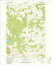
1982 Map of Mead Lake East
USGS Topo · Published 1982About this map
The South Fork Eau Claire River and Norwegian Creek meander through this rural section of Clark County, which was surveyed in the early 1980s. The landscape is defined by the transitions between the townships of Reseburg, Longwood, and Warner, where agricultural clearings meet denser woodland. In the southwest, Mead Lake is a prominent water feature, while the elevation rises toward North Mound, where a Lookout Tower stands near the small settlement of Kokaly. Local history is anchored by rural institutions like the Townhall and religious centers such as Immanuel Ch, located near the Immanuel Ch Cem. The eastern edge of the quadrangle is defined by the Black River, while several Gravel Pits suggest the area's local extraction industry during this era.
Find a feature on this map
20 named features on this map. Tap any name to fly to it.
Don’t see what you’re looking for? This feature index may not catch every label — zoom into the map to look around manually.
Map Details
Editions of this 1982 Mead Lake East Map
This is the sole edition of this map. No revisions or reprints were ever made.
Other maps of this area

1948 · Fairchild
USGS Topo · 1:62,500

1949 · Fairchild
USGS Topo · 1:62,500

1952 · Stanley
USGS Topo · 1:62,500

1953 · Neillsville
USGS Topo · 1:62,500

1953 · Owen
USGS Topo · 1:48,000

1953 · Eau Claire
USGS Topo · 1:250,000

1958 · Eau Claire
USGS Topo · 1:250,000

1963 · Owen
USGS Topo · 1:62,500

1964 · Eau Claire
USGS Topo · 1:250,000
1976 · Stanley NE
USGS Topo · 1:24,000