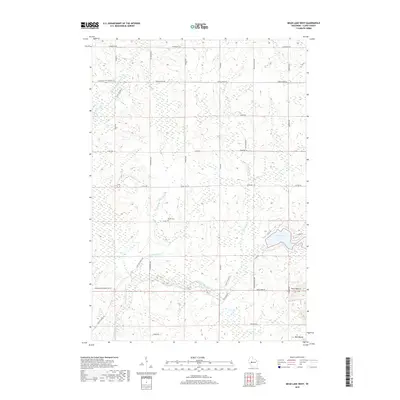
2018 Map of Mead Lake West
USGS Topo · Published 2018About this map
S Fork Eau Claire River and the North Fork Eau Claire River wind through this Clark County landscape, where the terrain is punctuated by distinctive rises such as North Mound and Mid Mound. The eastern portion of the sheet is defined by the waters of Mead Lake, while the western stretches contain the marshy expanse of Blue Swamp. A network of rural routes, including Foley School Rd and Worden Butler Townline RD, connects the scattered farmsteads and woodlots characteristic of the Reseburg area. Genealogy researchers will find the Butler Cem located near Drive Cole RD and Dickerson Ave, serving as a primary point of historical reference for the local community. The mapping reflects a landscape of small creeks like Black Cr and Robinson Cr that feed into the larger river systems, maintaining a pattern of land use centered on the natural drainage and elevation of the region.
Find a feature on this map
38 named features on this map. Tap any name to fly to it.
Don’t see what you’re looking for? This feature index may not catch every label — zoom into the map to look around manually.
Map Details
Editions of this 2018 Mead Lake West Map
This is the sole edition of this map. No revisions or reprints were ever made.
Other maps of this area

1948 · Fairchild
USGS Topo · 1:62,500

1949 · Fairchild
USGS Topo · 1:62,500

1952 · Stanley
USGS Topo · 1:62,500

1953 · Neillsville
USGS Topo · 1:62,500

1953 · Owen
USGS Topo · 1:48,000

1953 · Eau Claire
USGS Topo · 1:250,000

1958 · Eau Claire
USGS Topo · 1:250,000

1963 · Owen
USGS Topo · 1:62,500

1964 · Eau Claire
USGS Topo · 1:250,000
1976 · Stanley NE
USGS Topo · 1:24,000