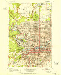
1973 Map of Mead
USGS Topo · Published 1977About this map
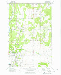
Peone Prairie and the heights of Orchard Bluff anchor this landscape north of Spokane during the early 1970s. The region is defined by its agricultural character and scattered institutions, such as the Mater Cleri Seminary and the Circle Bar J Boys Ranch. Transportation and industry center on the Burlington Northern railroad corridor, which serves the town of Mead and its massive Grain Elevator. Significant local history is preserved through labels like the Indian Treaty Tree on the southern edge of the prairie.
Find a feature on this map
70 named features on this map. Tap any name to fly to it.
Don’t see what you’re looking for? This feature index may not catch every label — zoom into the map to look around manually.
Map Details
Editions of this 1973 Mead Map
3 editions found
Other maps of this area

1901 · Spokane
USGS Topo · 1:125,000

1943 · Mt Spokane
USGS Topo · 1:62,500

1949 · Deer Park
USGS Topo · 1:62,500

1949 · Greenacres
USGS Topo · 1:62,500
1950 · Spokane NE
USGS Topo · 1:24,000

1950 · Mt Spokane
USGS Topo · 1:62,500
1950 · Spokane NW
USGS Topo · 1:24,000

1950 · Spokane
USGS Topo · 1:62,500
1951 · Deer Park
USGS Topo · 1:62,500

1951 · Greenacres
USGS Topo · 1:62,500