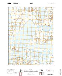
2020 Map of Meade River D-1 NE
USGS Topo · Published 2020About this map
Admiralty Bay defines the eastern edge of this Arctic landscape, where the Beaufort Sea meets the coastal tundra of the North Slope. This 2020 survey, produced from data gathered by the U.S. Geological Survey and other federal agencies, illustrates a complex network of thaw lakes and wetlands characteristic of this high-latitude environment. The most prominent freshwater feature is Sisgravik Lake, situated in the western interior. The map reveals the immense density of water bodies that dominate the region, often separated only by thin strips of land. These features provide essential data for understanding the hydrological patterns of the Alaskan tundra and the shifting shoreline of the Arctic coast.
Find a feature on this map
6 named features on this map. Tap any name to fly to it.
Don’t see what you’re looking for? This feature index may not catch every label — zoom into the map to look around manually.
Map Details
Editions of this 2020 Meade River D-1 NE Map
This is the sole edition of this map. No revisions or reprints were ever made.
Other maps of this area

1945 · Barrow
USGS Topo · 1:250,000

1949 · Barrow
USGS Topo · 1:250,000

1951 · Meade River
USGS Topo · 1:250,000

1951 · Teshekpuk
USGS Topo · 1:250,000

1955 · Barrow
USGS Topo · 1:250,000

1955 · Teshekpuk
USGS Topo · 1:250,000

1955 · Meade River
USGS Topo · 1:250,000

1955 · Barrow A-4
USGS Topo · 1:63,360

1955 · Barrow A-3
USGS Topo · 1:63,360
1955 · Teshekpuk D-5
USGS Topo · 1:63,360