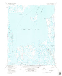
1955 Map of Teshekpuk D-5
USGS Topo · Published 1969About this map
Admiralty Bay and the northern Arctic coast are captured here in the mid-1950s, a period when this region was primarily characterized by its hydrology and the early indicators of its mineral potential. The map details the intricate Meade River Delta and the convergence of the Topagoruk River and Chipp River as they empty into the bay. Significant for the era's energy history, the presence of the Admiralty Oil Seep near the eastern shore points to the resource exploration occurring within what was then Naval Petroleum Reserve No. 4.
Find a feature on this map
16 named features on this map. Tap any name to fly to it.
Don’t see what you’re looking for? This feature index may not catch every label — zoom into the map to look around manually.
Map Details
Editions of this 1955 Teshekpuk D-5 Map
This is the sole edition of this map. No revisions or reprints were ever made.
Other maps of this area

1945 · Barrow
USGS Topo · 1:250,000

1949 · Barrow
USGS Topo · 1:250,000

1951 · Meade River
USGS Topo · 1:250,000

1951 · Teshekpuk
USGS Topo · 1:250,000

1955 · Barrow A-2
USGS Topo · 1:63,360

1955 · Barrow
USGS Topo · 1:250,000

1955 · Teshekpuk
USGS Topo · 1:250,000

1955 · Teshekpuk C-5
USGS Topo · 1:63,360

1955 · Teshekpuk C-4
USGS Topo · 1:63,360

1955 · Meade River
USGS Topo · 1:250,000