
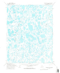
1955 Map of Teshekpuk C-5
USGS Topo · Published 1965About this map
Naval Petroleum Reserve No. 4 encompasses this entire expanse of Arctic tundra during the mid-1950s, characterized by a dense network of thaw lakes and meandering water systems. Exploration for energy resources is the primary human footprint on this landscape, anchored by the Topagoruk Test Well No 1 and an associated Camp. These remote outposts and transient settlements like Gotuk and Libby were linked by a series of seasonal routes, including a Tractor Trail and Winter Trail, which were essential for navigating the permafrost terrain before permanent infrastructure existed.
Find a feature on this map
12 named features on this map. Tap any name to fly to it.
Don’t see what you’re looking for? This feature index may not catch every label — zoom into the map to look around manually.
Map Details
Editions of this 1955 Teshekpuk C-5 Map
2 editions found
Other maps of this area

1951 · Meade River
USGS Topo · 1:250,000

1951 · Teshekpuk
USGS Topo · 1:250,000

1955 · Teshekpuk
USGS Topo · 1:250,000
1955 · Teshekpuk B-4
USGS Topo · 1:63,360

1955 · Teshekpuk C-4
USGS Topo · 1:63,360
1955 · Teshekpuk B-5
USGS Topo · 1:63,360

1955 · Meade River
USGS Topo · 1:250,000

1955 · Meade River B-1
USGS Topo · 1:63,360

1955 · Meade River C-1
USGS Topo · 1:63,360
1955 · Teshekpuk D-5
USGS Topo · 1:63,360