
1955 Map of Meade River B-1
USGS Topo · Published 1967About this map
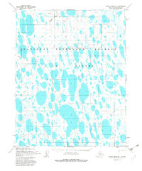
The Okpiksak River winds through this expanse of the North Slope, surrounded by a dense network of thaw lakes and ponds characteristic of the Arctic coastal plain. Photogrammetric methods from 1955 captured this landscape during a period of significant strategic interest, as the entire area falls within the Naval Petroleum Reserve No. 4. This designation reflects the era's focus on national energy security and exploration in the remote Alaskan interior. Transportation across this tundra environment was restricted to seasonal routes, evidenced by the Tractor Winter Trail and various Tractor Trails that provided the only overland access for surveyors and equipment during the mid-20th century. These ephemeral paths were essential for traversing the water-logged terrain before modern infrastructure reached the far north.
Find a feature on this map
4 named features on this map. Tap any name to fly to it.
Don’t see what you’re looking for? This feature index may not catch every label — zoom into the map to look around manually.
Map Details
Editions of this 1955 Meade River B-1 Map
2 editions found
Other maps of this area

1951 · Meade River
USGS Topo · 1:250,000

1951 · Teshekpuk
USGS Topo · 1:250,000

1955 · Teshekpuk
USGS Topo · 1:250,000

1955 · Teshekpuk C-5
USGS Topo · 1:63,360
1955 · Teshekpuk A-5
USGS Topo · 1:63,360
1955 · Teshekpuk B-5
USGS Topo · 1:63,360

1955 · Meade River
USGS Topo · 1:250,000

1955 · Meade River A-2
USGS Topo · 1:63,360

1955 · Meade River B-2
USGS Topo · 1:63,360

1955 · Meade River C-1
USGS Topo · 1:63,360