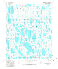
1955 Map of Meade River B-1
USGS Topo · Published 1982About this map
The National Petroleum Reserve in Alaska dominates this landscape on the North Slope, characterized by a complex network of thousands of small thaw lakes and interconnected wetlands. Transportation in this mid-century period relied heavily on seasonal routes, evidenced by the numerous Winter Tractor Trails and Tractor Trails that crisscross the tundra. These routes were essential for navigating the low-lying terrain during the frozen months when the ground could support heavy equipment.
Find a feature on this map
10 named features on this map. Tap any name to fly to it.
Don’t see what you’re looking for? This feature index may not catch every label — zoom into the map to look around manually.
Map Details
Editions of this 1955 Meade River B-1 Map
2 editions found
Other maps of this area

1951 · Meade River
USGS Topo · 1:250,000

1951 · Teshekpuk
USGS Topo · 1:250,000

1955 · Teshekpuk
USGS Topo · 1:250,000

1955 · Teshekpuk C-5
USGS Topo · 1:63,360
1955 · Teshekpuk A-5
USGS Topo · 1:63,360
1955 · Teshekpuk B-5
USGS Topo · 1:63,360

1955 · Meade River
USGS Topo · 1:250,000

1955 · Meade River B-1
USGS Topo · 1:63,360

1955 · Meade River A-2
USGS Topo · 1:63,360

1955 · Meade River B-2
USGS Topo · 1:63,360