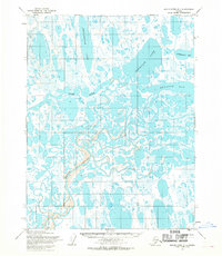
1955 Map of Meade River D-1
USGS Topo · Published 1970About this map
Naval Petroleum Reserve No. 4 encompasses this entire coastal landscape, characterized by an intricate network of thaw lakes and meandering waterways on Alaska's North Slope. The terrain is dominated by the wide, winding paths of the Inaru River and Meade River, which snake through the tundra before reaching the Arctic waters. Along the Inaru, a lone Cabin and a dedicated Fish Camp suggest the seasonal subsistence patterns of the region's inhabitants during the mid-1950s. To the north, large bodies of water such as Ekalgruak Lake and Sisgravik Lake fill the coastal plain, eventually giving way to the saltwater of Kuyanak Bay and Admiralty Bay. A solitary Tractor Trail in the southwest corner provides a rare trace of overland transport in this remote environment.
Find a feature on this map
10 named features on this map. Tap any name to fly to it.
Don’t see what you’re looking for? This feature index may not catch every label — zoom into the map to look around manually.
Map Details
Editions of this 1955 Meade River D-1 Map
This is the sole edition of this map. No revisions or reprints were ever made.
Other maps of this area

1945 · Barrow
USGS Topo · 1:250,000

1949 · Barrow
USGS Topo · 1:250,000

1951 · Meade River
USGS Topo · 1:250,000

1951 · Teshekpuk
USGS Topo · 1:250,000

1955 · Barrow
USGS Topo · 1:250,000

1955 · Teshekpuk
USGS Topo · 1:250,000

1955 · Teshekpuk C-5
USGS Topo · 1:63,360

1955 · Meade River
USGS Topo · 1:250,000

1955 · Barrow A-4
USGS Topo · 1:63,360

1955 · Barrow A-3
USGS Topo · 1:63,360