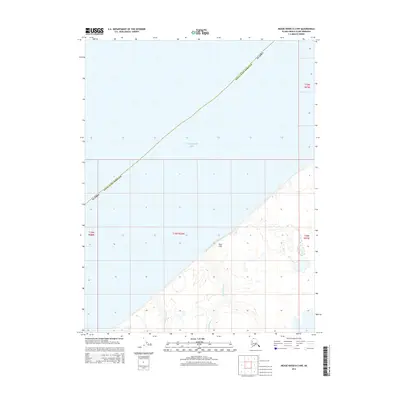
2014 Map of Meade River D-3 NW
USGS Topo · Published 2014About this map
Skull Cliff marks a dramatic transition from the tundra to the coast of the Chukchi Sea along the northwestern edge of the Alaska North Slope Borough. The landscape is characterized by its hydrological patterns, where small drainage systems such as Tuapaktushak Cr and Kikaligarak Cr wind through the coastal plain toward the sea. This 2014 survey documents the topography of a remote stretch of the Arctic shoreline, emphasizing the interaction between terrestrial features and the maritime environment. The area is defined by its lack of established roads or permanent settlements, showcasing the untouched nature of the Alaskan coast near the mouth of these small creeks.
Find a feature on this map
9 named features on this map. Tap any name to fly to it.
Don’t see what you’re looking for? This feature index may not catch every label — zoom into the map to look around manually.
Map Details
Editions of this 2014 Meade River D-3 NW Map
This is the sole edition of this map. No revisions or reprints were ever made.
Other maps of this area

1945 · Barrow
USGS Topo · 1:250,000

1949 · Barrow
USGS Topo · 1:250,000

1951 · Meade River
USGS Topo · 1:250,000

1955 · Barrow
USGS Topo · 1:250,000

1955 · Meade River
USGS Topo · 1:250,000

1955 · Barrow A-5
USGS Topo · 1:63,360
1955 · Meade River D-4
USGS Topo · 1:63,360

1955 · Meade River D-3
USGS Topo · 1:63,360
1962 · Meade River D-3
USGS Topo · 1:50,000
1962 · Meade River D-4
USGS Topo · 1:50,000