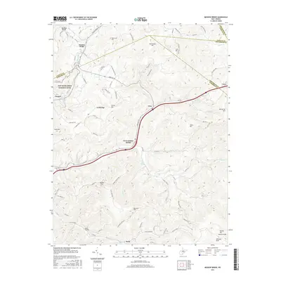
2016 Map of Meadow Bridge
USGS Topo · Published 2016About this map
Meadow Bridge and the surrounding highlands of the central West Virginia Plateau are defined by high-elevation settlements and the deep drainages of the New River watershed. The map details a landscape where traditional Appalachian communities like Lockbridge, Elton, and Lawn are connected by winding county roads such as Sandstone Rd and Meadow Bridge Rd. A notable feature of this area is the Green Sulphur Springs community, named for the mineral Green Sulphur Spring located nearby. The topography is dominated by prominent peaks including Beelick Knob, Patterson Mtn, and Big Swell Mtn, which frame the narrow creek valleys. In the northwest corner, the protected lands of the New River Gorge National River begin to descend toward the gorge, while family history is preserved at sites like Wickline Cem and Bragg Cem.
Find a feature on this map
98 named features on this map. Tap any name to fly to it.
Don’t see what you’re looking for? This feature index may not catch every label — zoom into the map to look around manually.
Map Details
Editions of this 2016 Meadow Bridge Map
This is the sole edition of this map. No revisions or reprints were ever made.
Other maps of this area

1887 · Hinton
USGS Topo · 1:125,000

1892 · Hinton
USGS Topo · 1:125,000

1912 · Meadow Creek
USGS Topo · 1:48,000

1912 · Big Bend
USGS Topo · 1:62,500

1914 · Big Bend
USGS Topo · 1:62,500

1915 · Meadow Creek
USGS Topo · 1:62,500

1921 · Alderson
USGS Topo · 1:48,000

1921 · Clintonville
USGS Topo · 1:48,000

1923 · Clintonville
USGS Topo · 1:62,500
1923 · Alderson
USGS Topo · 1:62,500