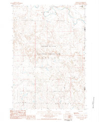
1983 Map of Meadow NE
USGS Topo · Published 1984About this map
The Grand River meanders across this Perkins County landscape, defining a wide valley within the Grand River National Grassland. This 1980s era survey documents the rural subdivisions of Dewitt, Hudgins, Clark, and Whitney, where the land is marked by isolated features like the Spade terrain landmark and scattered water sources such as Thunder Hawk Creek. The map reflects a sparsely populated region of South Dakota focused on conservation and ranching, as indicated by the prominent Grassland Boundary. Researchers will find a detailed look at the section lines and topography that governed the area's development during the late twentieth century, showing the relationship between the natural waterway and the designated protected grasslands.
Find a feature on this map
11 named features on this map. Tap any name to fly to it.
Don’t see what you’re looking for? This feature index may not catch every label — zoom into the map to look around manually.
Map Details
Editions of this 1983 Meadow NE Map
This is the sole edition of this map. No revisions or reprints were ever made.
Other maps of this area

1953 · McIntosh
USGS Topo · 1:250,000

1954 · Lemmon
USGS Topo · 1:250,000

1957 · Lemmon
USGS Topo · 1:250,000

1958 · McIntosh
USGS Topo · 1:250,000

1972 · Black Horse Butte NW
USGS Topo · 1:24,000

1972 · Black Horse Butte
USGS Topo · 1:24,000

1972 · Thunder Hawk SW
USGS Topo · 1:24,000

1980 · McIntosh
USGS Topo · 1:100,000
1983 · Lemmon Lake
USGS Topo · 1:24,000

1983 · Meadow NW
USGS Topo · 1:24,000