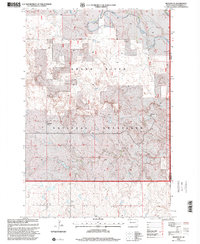
1998 Map of Meadow NE
USGS Topo · Published 2001About this map
Grand River National Grassland dominates this portion of the northern plains, where the Grand River meanders across the border of Perkins and Corson counties. This late-twentieth-century landscape is defined by vast rangelands and localized ranching operations, such as the O Wiesinger Ranch and H Wiesinger Ranch. The importance of water management in this semi-arid environment is evident through the notation of various Windmills, a Spring, and a Well scattered across the township sections. Natural features like the Prairie Dog Town illustrate the preservation of native prairie ecology within the national grassland. The map reveals the cadastral legacy of the region through the large-scale township divisions of De Witt, Clark, and Whitney, providing a clear look at the dispersed settlement patterns typical of rural South Dakota at the turn of the millennium.
Find a feature on this map
12 named features on this map. Tap any name to fly to it.
Don’t see what you’re looking for? This feature index may not catch every label — zoom into the map to look around manually.
Map Details
Editions of this 1998 Meadow NE Map
This is the sole edition of this map. No revisions or reprints were ever made.
Other maps of this area

1953 · McIntosh
USGS Topo · 1:250,000

1954 · Lemmon
USGS Topo · 1:250,000

1957 · Lemmon
USGS Topo · 1:250,000

1958 · McIntosh
USGS Topo · 1:250,000

1972 · Black Horse Butte NW
USGS Topo · 1:24,000

1972 · Black Horse Butte
USGS Topo · 1:24,000

1972 · Thunder Hawk SW
USGS Topo · 1:24,000

1980 · McIntosh
USGS Topo · 1:100,000
1983 · Lemmon Lake
USGS Topo · 1:24,000

1983 · Meadow NW
USGS Topo · 1:24,000