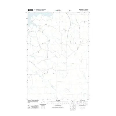
2012 Map of Meadow NW
USGS Topo · Published 2012About this map
Shadehill Reservoir defines the northwestern corner of this Perkins County landscape, where the waters reach into the drainages of the high plains. The terrain is structured by a grid of rural routes and historical thoroughfares, most notably Old US Hwy 73, which runs north-to-south through the center of the quadrangle. This area of South Dakota exhibits a transition from water-managed reservoir shores to the open grazing lands typical of the region. Local travel is facilitated by named arteries such as S Cabin Rd and Bald Butte Rd, reflecting the ranching and agricultural foundations of the community. Other local landmarks like Hudgins Rd and Pasture 8 Rd provide a clear view of how land was partitioned and accessed in the early 21st century.
Find a feature on this map
16 named features on this map. Tap any name to fly to it.
Don’t see what you’re looking for? This feature index may not catch every label — zoom into the map to look around manually.
Map Details
Editions of this 2012 Meadow NW Map
This is the sole edition of this map. No revisions or reprints were ever made.
Other maps of this area

1954 · Lemmon
USGS Topo · 1:250,000

1957 · Lemmon
USGS Topo · 1:250,000

1983 · Haynes SE
USGS Topo · 1:24,000

1983 · Boxcar Buttes
USGS Topo · 1:24,000
1983 · Lemmon Lake
USGS Topo · 1:24,000

1983 · Bison NE
USGS Topo · 1:24,000

1983 · Meadow NW
USGS Topo · 1:24,000

1983 · Meadow
USGS Topo · 1:24,000
1983 · Meadow SE
USGS Topo · 1:24,000
1983 · Meadow NE
USGS Topo · 1:24,000