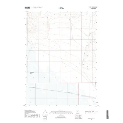
2020 Map of Meadow Spring
USGS Topo · Published 2020About this map
The Hogup rail point and the extensive Newfoundland Evaporation Basin define this arid landscape in Box Elder County. This 2020 survey highlights a remote industrial and hydrologic corridor where the Rio Buenaventura Canal cuts across the salt flats. The topography is dominated by the stark rise of Broom Mtn, while the eponymous Meadow Spring provides a rare hydrologic marker in the western flats. A network of utilitarian roads, including Middle Pass Rd and Railroad Siding Rd, provides access to this desolate stretch of the Great Salt Lake Desert, illustrating the intersection of modern salt-resource management and historical rail infrastructure.
Find a feature on this map
11 named features on this map. Tap any name to fly to it.
Don’t see what you’re looking for? This feature index may not catch every label — zoom into the map to look around manually.
Map Details
Editions of this 2020 Meadow Spring Map
This is the sole edition of this map. No revisions or reprints were ever made.
Other maps of this area

1954 · Brigham City
USGS Topo · 1:250,000

1958 · Brigham City
USGS Topo · 1:250,000

1962 · Brigham City
USGS Topo · 1:250,000

1969 · Dolphin Island West
USGS Topo · 1:24,000

1969 · Hogup Ridge South
USGS Topo · 1:24,000

1969 · Hogup Ridge North
USGS Topo · 1:24,000

1983 · Desert Peak
USGS Topo · 1:24,000

1983 · Round Mountain NW
USGS Topo · 1:24,000

1983 · Sheep Mountain
USGS Topo · 1:24,000

1983 · Groome
USGS Topo · 1:24,000