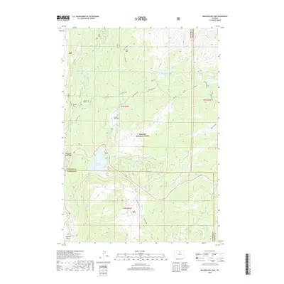
2018 Map of Meadowlark Lake
USGS Topo · Published 2018About this map
Meadow Lark Lake and the adjacent Tensleep Reservoir serve as central landmarks in this high-elevation landscape within the Bighorn National Forest. The map detail traces the intricate drainage systems of the Bighorn Mountains, where Middle Tensleep Cr and E Tensleep Cr carve through the terrain. Named clearings such as Sitting Bull Park, Bear Park, and Island Park indicate the open meadowlands that break the forested slopes. To the southwest, the dramatic descent into Tensleep Canyon is documented, alongside the rugged course of Stovepipe Cr and Squaw Cr. High-elevation lakes including Lake McLain and Maybelle Lake are accessible via routes like Mclain and the Lake Creek ATV trail, reflecting the area's use for recreation and water management near the border of Big Horn and Washakie counties.
Find a feature on this map
39 named features on this map. Tap any name to fly to it.
Don’t see what you’re looking for? This feature index may not catch every label — zoom into the map to look around manually.
Map Details
Editions of this 2018 Meadowlark Lake Map
This is the sole edition of this map. No revisions or reprints were ever made.
Other maps of this area

1899 · Cloud peak
USGS Topo · 1:125,000

1901 · Cloud Peak
USGS Topo · 1:125,000

1955 · Sheridan
USGS Topo · 1:250,000

1958 · Sheridan
USGS Topo · 1:250,000

1960 · Lake Solitude
USGS Topo · 1:24,000

1962 · Sheridan
USGS Topo · 1:250,000
1967 · Onion Gulch
USGS Topo · 1:24,000
1967 · Old Maid Gulch
USGS Topo · 1:24,000

1967 · Brokenback Narrows
USGS Topo · 1:24,000
1967 · Hazelton Peak
USGS Topo · 1:24,000