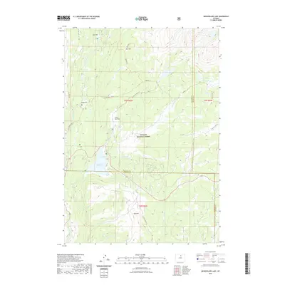
2021 Map of Meadowlark Lake
USGS Topo · Published 2021About this map
The Bighorn National Forest landscape across the Big Horn, Johnson, and Washakie county lines is defined by a high-elevation drainage network centered on Tensleep Reservoir. This 2021 survey illustrates a wilderness defined by its named parks and alpine basins, including Bear Park, Deer Park, and Sitting Bull Park. The hydrology is complex, with Middle Tensleep Cr and W Tensleep Cr feeding into the larger reservoir system. Recreational and historical access is marked by an extensive trail network, featuring the Highline Trl and the Lake Creek Atv Trl. From the heights of Bald Ridge to the waters of Lake McLain and Maybelle Lake, the map captures a modern view of this primitive backcountry as it remains managed for public use and conservation.
Find a feature on this map
39 named features on this map. Tap any name to fly to it.
Don’t see what you’re looking for? This feature index may not catch every label — zoom into the map to look around manually.
Map Details
Editions of this 2021 Meadowlark Lake Map
This is the sole edition of this map. No revisions or reprints were ever made.
Other maps of this area

1899 · Cloud peak
USGS Topo · 1:125,000

1901 · Cloud Peak
USGS Topo · 1:125,000

1955 · Sheridan
USGS Topo · 1:250,000

1958 · Sheridan
USGS Topo · 1:250,000

1960 · Lake Solitude
USGS Topo · 1:24,000

1962 · Sheridan
USGS Topo · 1:250,000
1967 · Onion Gulch
USGS Topo · 1:24,000
1967 · Old Maid Gulch
USGS Topo · 1:24,000

1967 · Brokenback Narrows
USGS Topo · 1:24,000
1967 · Hazelton Peak
USGS Topo · 1:24,000