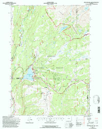
1993 Map of Meadowlark Lake
USGS Topo · Published 1997About this map
Meadowlark Lake and the surrounding high-altitude terrain of the Bighorn National Forest anchor this 1993 study of north-central Wyoming. The landscape is defined by the convergence of Big Horn, Washakie, and Johnson counties, where the Skyway Scenic Byway winds through alpine parks and recreational sites. Settlement is sparse and focused on seasonal use, evidenced by the presence of Meadowlark Lodge, Deer Haven Lodge, and the chapel St Christopher in the Bighorn.
Find a feature on this map
48 named features on this map. Tap any name to fly to it.
Don’t see what you’re looking for? This feature index may not catch every label — zoom into the map to look around manually.
Map Details
Editions of this 1993 Meadowlark Lake Map
This is the sole edition of this map. No revisions or reprints were ever made.
Other maps of this area

1899 · Cloud peak
USGS Topo · 1:125,000

1901 · Cloud Peak
USGS Topo · 1:125,000

1955 · Sheridan
USGS Topo · 1:250,000

1958 · Sheridan
USGS Topo · 1:250,000

1960 · Lake Solitude
USGS Topo · 1:24,000

1962 · Sheridan
USGS Topo · 1:250,000
1967 · Onion Gulch
USGS Topo · 1:24,000
1967 · Old Maid Gulch
USGS Topo · 1:24,000

1967 · Brokenback Narrows
USGS Topo · 1:24,000
1967 · Hazelton Peak
USGS Topo · 1:24,000