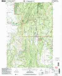
2004 Map of Meadows
USGS Topo · Published 2007About this map
Meadows Valley Cem and the historic Packer Johns Cabin State Park anchor the western portion of this Idaho landscape, where the agricultural flats of Meadows Valley meet the rising slopes of the Payette National Forest. This 2004 revision, based on earlier surveys, reveals the distinct topography between the older settlement at Meadows and the more developed corridors near McCall. The geography is defined by a network of drainage ditches and mountain streams, including East Branch Meadows Creek and Threemile Creek, which supported local ranching and transit long before the establishment of modern recreation sites like the Payette Lake Ski Area.
Find a feature on this map
37 named features on this map. Tap any name to fly to it.
Don’t see what you’re looking for? This feature index may not catch every label — zoom into the map to look around manually.
Map Details
Editions of this 2004 Meadows Map
This is the sole edition of this map. No revisions or reprints were ever made.
Other maps of this area

1911 · Meadows
USGS Topo · 1:125,000

1938 · Riggins
USGS Topo · 1:96,000

1945 · Riggins
USGS Topo · 1:125,000

1954 · New Meadows
USGS Topo · 1:62,500

1955 · Baker
USGS Topo · 1:250,000

1955 · Grangeville
USGS Topo · 1:250,000

1959 · Baker
USGS Topo · 1:250,000

1959 · Grangeville
USGS Topo · 1:250,000

1963 · Bally Mountain
USGS Topo · 1:24,000

1963 · Granite Lake
USGS Topo · 1:24,000