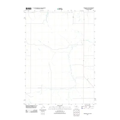
2011 Map of Meadville NE
USGS Topo · Published 2011About this map
Holt Creek and Timber Creek meander across this section of the Great Plains in Keya Paha County, defining a landscape primarily shaped by cattle ranching and sparse rural infrastructure. The most prominent human-made landmark is the Gierau Ranch, situated in the northern reaches of the quadrangle near the South Dakota border. This 2011 survey documents the intersection of long-established ranching tracts with the primary transportation artery of Highway 183, which runs north-to-south through the center of the region. A network of rural gravel and section-line roads, including 304th St and Timber Creek Rd, provide access to the vast grazing lands that characterize this remote portion of Nebraska's northern borderlands.
Find a feature on this map
7 named features on this map. Tap any name to fly to it.
Don’t see what you’re looking for? This feature index may not catch every label — zoom into the map to look around manually.
Map Details
Editions of this 2011 Meadville NE Map
This is the sole edition of this map. No revisions or reprints were ever made.
Other maps of this area

1950 · Meadville
USGS Topo · 1:24,000

1950 · Huddle Table
USGS Topo · 1:24,000

1955 · Mitchell
USGS Topo · 1:250,000

1955 · O'Neill
USGS Topo · 1:250,000

1959 · O'Neill
USGS Topo · 1:250,000

1959 · Mitchell
USGS Topo · 1:250,000

1964 · Dallas SW
USGS Topo · 1:24,000
1964 · Meadville NW
USGS Topo · 1:24,000
1964 · Springview
USGS Topo · 1:24,000
1964 · Springview NW
USGS Topo · 1:24,000