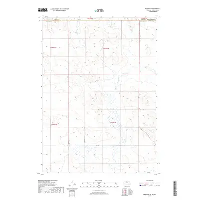
2017 Map of Meadville NE
USGS Topo · Published 2017About this map
Keya Paha County's remote northern ranching country is documented here along the state line where Nebraska meets South Dakota. The landscape is defined by the drainage basins of Holt Cr and Timber Cr, which carve through the high plains terrain. Local land use and ownership in this sparsely populated region are noted by specific named markers such as Gerald Titus, Furgh Son, and Caulfield, which serve as significant landmarks for local history and property research. Transportation is limited to a handful of rural corridors, including Crouse and 304th St, as well as Highway 183, which provides the primary north-south connection across the state boundary into Tripp County. This survey highlights the intersection of public land management and private ranching interests in a region where geography is shaped by water access and section lines.
Find a feature on this map
18 named features on this map. Tap any name to fly to it.
Don’t see what you’re looking for? This feature index may not catch every label — zoom into the map to look around manually.
Map Details
Editions of this 2017 Meadville NE Map
This is the sole edition of this map. No revisions or reprints were ever made.
Other maps of this area

1950 · Meadville
USGS Topo · 1:24,000

1950 · Huddle Table
USGS Topo · 1:24,000

1955 · Mitchell
USGS Topo · 1:250,000

1955 · O'Neill
USGS Topo · 1:250,000

1959 · O'Neill
USGS Topo · 1:250,000

1959 · Mitchell
USGS Topo · 1:250,000

1964 · Dallas SW
USGS Topo · 1:24,000
1964 · Meadville NW
USGS Topo · 1:24,000
1964 · Springview
USGS Topo · 1:24,000
1964 · Springview NW
USGS Topo · 1:24,000