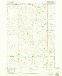
1964 Map of Meadville NE
USGS Topo · Published 1965About this map
Rosebud Indian Reservation territory defines the northern border of this Nebraska landscape, where the state line meets the South Dakota Nebraska boundary. The terrain is a network of creek drainages, notably Timber Creek and Holt Creek, which carve through the land in an area marked by rural independence. Small community hubs are anchored by local education sites like West Enterprise Sch and Liberty School, reflecting the mid-century distribution of homesteads and ranches in Keya Paha Co and neighboring Tripp Co.
Find a feature on this map
12 named features on this map. Tap any name to fly to it.
Don’t see what you’re looking for? This feature index may not catch every label — zoom into the map to look around manually.
Map Details
Editions of this 1964 Meadville NE Map
This is the sole edition of this map. No revisions or reprints were ever made.
Other maps of this area

1950 · Meadville
USGS Topo · 1:24,000

1950 · Huddle Table
USGS Topo · 1:24,000

1955 · Mitchell
USGS Topo · 1:250,000

1955 · O'Neill
USGS Topo · 1:250,000

1959 · O'Neill
USGS Topo · 1:250,000

1959 · Mitchell
USGS Topo · 1:250,000

1964 · Dallas SW
USGS Topo · 1:24,000
1964 · Meadville NW
USGS Topo · 1:24,000
1964 · Springview
USGS Topo · 1:24,000
1964 · Springview NW
USGS Topo · 1:24,000