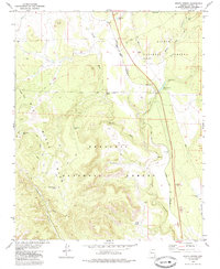
1979 Map of Meath Spring
USGS Topo · Published 1985About this map
The Atchison Topeka and Santa Fe railroad corridor cuts through this high-country landscape, bridging the boundary between the Kaibab National Forest and the Prescott National Forest. This 1970s survey captures a transition in transportation history, where an Old Railroad Grade winds through the southwestern section near Limestone Canyon, distinct from the active mainline. The importance of water management in this arid environment is evident by the dense network of catchments like Meath Spring, Railroad Fill Tank, and Wash Out Tank. Landforms such as Big Black Mesa and the steep incisions of Hell Canyon dominate the topography, while industrial activity is marked by scattered Cinder Pit and Borrow Pit sites, likely supporting the maintenance of the nearby rail lines and roads.
Find a feature on this map
25 named features on this map. Tap any name to fly to it.
Don’t see what you’re looking for? This feature index may not catch every label — zoom into the map to look around manually.
Map Details
Editions of this 1979 Meath Spring Map
2 editions found
Other maps of this area

1886 · Chino
USGS Topo · 1:250,000

1887 · Prescott
USGS Topo · 1:250,000

1891 · Chino
USGS Topo · 1:250,000

1892 · Prescott
USGS Topo · 1:250,000

1905 · Jerome
USGS Topo · 1:125,000

1922 · Williams
USGS Topo · 1:125,000

1947 · Ash Fork
USGS Topo · 1:62,500

1947 · Simmons
USGS Topo · 1:62,500

1947 · Picacho Butte
USGS Topo · 1:62,500

1947 · Paulden
USGS Topo · 1:62,500