
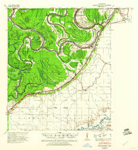
1940 Map of Mechanicsburg
USGS Topo · Published 1947About this map
Yazoo River commerce and the intricate drainage of the Delta dominate this 1940s landscape, where river landings served as the primary hubs for local agriculture. The topography is defined by the sharp escarpment that separates the alluvial floodplains from the higher ground to the east, a transition that dictated the placement of settlements like Satartia and Mechanicsburg. Along the winding watercourses, numerous steamboat landings such as Horn Place Ldg, Enola Ldg, and Nyans L'argent Ldg highlight a river-dependent economy in transition during the years following the Flood Control Act.
Find a feature on this map
42 named features on this map. Tap any name to fly to it.
Don’t see what you’re looking for? This feature index may not catch every label — zoom into the map to look around manually.
Map Details
Editions of this 1940 Mechanicsburg Map
2 editions found
Other maps of this area

1903 · Jackson
USGS Topo · 1:125,000

1918 · Vicksburg
USGS Topo · 1:62,500

1934 · Raymond
USGS Topo · 1:48,000

1937 · Raymond
USGS Topo · 1:62,500

1938 · Edwards
USGS Topo · 1:62,500

1939 · Onward
USGS Topo · 1:62,500

1939 · Lorenzen
USGS Topo · 1:62,500

1941 · Vicksburg
USGS Topo · 1:62,500

1942 · Raymond
USGS Topo · 1:62,500

1955 · Jackson
USGS Topo · 1:250,000