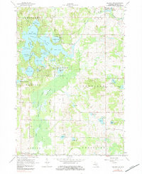
1964 Map of Mecosta
USGS Topo · Published 1984About this map
Chippewa River waters and the vast wetlands of Hughes Swamp define this mid-1960s landscape in Mecosta County. The area is dominated by an intricate system of glacial lakes, including Big Evans Lake, Tubbs Lake, and Diamond Lake, which form a recreational hub within the Martiny State Forest. This survey captures the rural infrastructure of the era, from the small village of Barryton in the northeast corner to the remote Johnsons Landing Field. Researchers can identify several local landmarks that anchor the community's history, such as Sheridan Ch, Pine Grove Ch, and the Mount Hope Cem near the southern boundary. Industrial activity is represented by scattered Gravel Pits and a Gas Well, reflecting the local economy's reliance on natural resources. The inclusion of the Winchester Dam illustrates the early management of the region's water levels for wildlife and conservation.
Find a feature on this map
53 named features on this map. Tap any name to fly to it.
Don’t see what you’re looking for? This feature index may not catch every label — zoom into the map to look around manually.
Map Details
Editions of this 1964 Mecosta Map
2 editions found
Other maps of this area

1954 · Midland
USGS Topo · 1:250,000

1958 · Midland
USGS Topo · 1:250,000

1958 · Big Rapids
USGS Topo · 1:62,500

1959 · Midland
USGS Topo · 1:250,000

1959 · Howard City
USGS Topo · 1:62,500

1964 · Edmore
USGS Topo · 1:24,000

1964 · Six Lakes
USGS Topo · 1:24,000

1964 · Mecosta NW
USGS Topo · 1:24,000

1964 · Blanchard
USGS Topo · 1:24,000

1964 · Mecosta
USGS Topo · 1:24,000