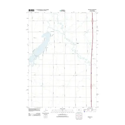
2012 Map of Medary
USGS Topo · Published 2012About this map
Lake Campbell and its surrounding glacial landscape define this section of Brookings County, where the Lake Campbell Resort serves as a focal point for local recreation. The waters of the lake drain through the Lake Campbell Outlet into the meandering Big Sioux River, which carves a winding path across the eastern prairie. For genealogists and local historians, the Lake Campbell Cem provides a significant point of reference near the northwestern shoreline. The settlement of Medary and the nearby Medary Cr reflect the area's early territorial importance. The landscape is structured by a rigorous section-line grid, featuring local routes such as Amen Cor and Bortnem Beach Rd, while the eastern edge of the map is dominated by a major north-south transportation corridor.
Find a feature on this map
32 named features on this map. Tap any name to fly to it.
Don’t see what you’re looking for? This feature index may not catch every label — zoom into the map to look around manually.
Map Details
Editions of this 2012 Medary Map
This is the sole edition of this map. No revisions or reprints were ever made.
Other maps of this area

1953 · Watertown
USGS Topo · 1:250,000

1958 · Watertown
USGS Topo · 1:250,000

1964 · Brookings
USGS Topo · 1:24,000

1964 · Medary
USGS Topo · 1:24,000

1964 · Rutland SE
USGS Topo · 1:24,000

1964 · Flandreau SW
USGS Topo · 1:24,000

1964 · Flandreau NW
USGS Topo · 1:24,000

1964 · Aurora
USGS Topo · 1:24,000

1968 · Volga
USGS Topo · 1:24,000
1968 · Rutland
USGS Topo · 1:24,000