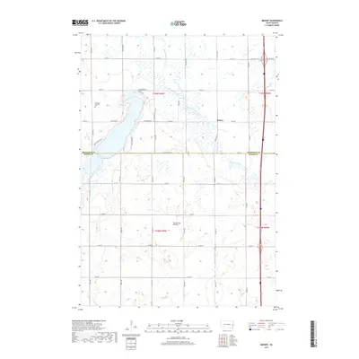
2017 Map of Medary
USGS Topo · Published 2017About this map
Medary sits at the heart of this prairie landscape, where the Big Sioux River winds southward through a network of wetlands and agricultural tracts. This 2017 survey shows the transition from the eastern edge of the Coteau des Prairies down toward the river valley, a region historically vital for its water resources and grazing lands. Along the western edge, the influence of Lake Campbell is visible through features like Lakeshore Dr and Bortnem Beach Rd, pointing to the area's development as a lakeside community. Genealogists and local historians will find the East Lake Campbell Cem north of these developments, providing a fixed point of reference for early settlement families. The map also documents the modern infrastructure of Brookings County and Moody County, including the path of S Dakota Hwy 324 crossing the river near the township boundary.
Find a feature on this map
78 named features on this map. Tap any name to fly to it.
Don’t see what you’re looking for? This feature index may not catch every label — zoom into the map to look around manually.
Map Details
Editions of this 2017 Medary Map
This is the sole edition of this map. No revisions or reprints were ever made.
Other maps of this area

1953 · Watertown
USGS Topo · 1:250,000

1958 · Watertown
USGS Topo · 1:250,000

1964 · Brookings
USGS Topo · 1:24,000

1964 · Medary
USGS Topo · 1:24,000

1964 · Rutland SE
USGS Topo · 1:24,000

1964 · Flandreau SW
USGS Topo · 1:24,000

1964 · Flandreau NW
USGS Topo · 1:24,000

1964 · Aurora
USGS Topo · 1:24,000

1968 · Volga
USGS Topo · 1:24,000
1968 · Rutland
USGS Topo · 1:24,000