1940 Map of Medfield
USGS Topo · Published 1940About this map
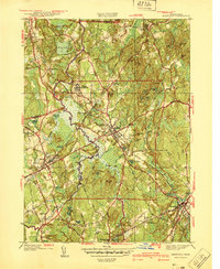
The Charles River winds through this 1930s landscape, defining the boundaries and drainage of a region transitioning from rural agricultural roots to a suburban-institutional character. A massive footprint is occupied by the Medfield State Hospital and its associated Filtration Plant and Sewage Disposal infrastructure, showing the scale of early 20th-century state facilities. Settlement is concentrated in the village centers of Medfield and Millis, both served by the New York New Haven and Hartford railroad line.
Find a feature on this map
88 named features on this map. Tap any name to fly to it.
Don’t see what you’re looking for? This feature index may not catch every label — zoom into the map to look around manually.
Map Details
Editions of this 1940 Medfield Map
2 editions found

Other maps of this area

1886 · Dedham
USGS Topo · 1:62,500

1886 · Framingham
USGS Topo · 1:62,500

1887 · Franklin
USGS Topo · 1:62,500

1889 · Franklin
USGS Topo · 1:62,500

1889 · Framingham
USGS Topo · 1:62,500

1893 · Franklin
USGS Topo · 1:62,500

1893 · Boston
USGS Topo · 1:62,500

1894 · Dedham
USGS Topo · 1:62,500

1894 · Framingham
USGS Topo · 1:62,500

1903 · Boston
USGS Topo · 1:62,500