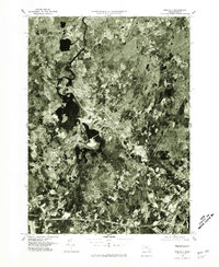
1977 Map of Medfield
USGS Topo · Published 1981About this map
The Charles River winds through the heart of Norfolk County in this 1977 orthophotoquad, which uses aerial imagery to show the land exactly as it appeared in the late seventies. The settlement of Medfield serves as a central hub, surrounded by the neighboring communities of Sherborn, Millis, and Dover. Unlike traditional topographic maps, this photographic survey provides a literal view of property boundaries, forest cover, and the expanding residential footprints of Harding and Walpole. The imagery reveals a landscape where dense suburban growth meets the persistent wetlands and floodplains of the river valley, offering researchers a precise record of late-twentieth-century land use and suburban development in Massachusetts.
Find a feature on this map
7 named features on this map. Tap any name to fly to it.
Don’t see what you’re looking for? This feature index may not catch every label — zoom into the map to look around manually.
Map Details
Editions of this 1977 Medfield Map
This is the sole edition of this map. No revisions or reprints were ever made.
Other maps of this area

1886 · Dedham
USGS Topo · 1:62,500

1886 · Framingham
USGS Topo · 1:62,500

1887 · Franklin
USGS Topo · 1:62,500

1889 · Franklin
USGS Topo · 1:62,500

1889 · Framingham
USGS Topo · 1:62,500

1893 · Franklin
USGS Topo · 1:62,500

1893 · Boston
USGS Topo · 1:62,500

1894 · Dedham
USGS Topo · 1:62,500

1894 · Framingham
USGS Topo · 1:62,500

1903 · Boston
USGS Topo · 1:62,500