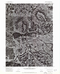
1974 Map of Medford NW
USGS Topo · Published 1978About this map
Central Point serves as the primary hub of development in this orthophotoquad, which uses 1974 aerial photography to document the landscape of Jackson County. The community of Midway and the northern reach of Sams Valley illustrate the varying density of human settlement across the region. The natural geography is defined by the winding course of the Rogue River, which cuts through the center of the sheet, and the massive, flat-topped silhouettes of Upper Table Rock and Lower Table Rock. These volcanic plateaus dominate the northern terrain, creating a sharp contrast between the elevated mesas and the fertile, patterned agricultural fields of the river valley below.
Find a feature on this map
6 named features on this map. Tap any name to fly to it.
Don’t see what you’re looking for? This feature index may not catch every label — zoom into the map to look around manually.
Map Details
Editions of this 1974 Medford NW Map
This is the sole edition of this map. No revisions or reprints were ever made.
Other maps of this area

1891 · Ashland
USGS Topo · 1:250,000

1893 · Ashland
USGS Topo · 1:250,000

1897 · Ashland
USGS Topo · 1:250,000

1904 · Riddle
USGS Topo · 1:125,000

1908 · Grants Pass
USGS Topo · 1:125,000

1938 · Medford
USGS Topo · 1:125,000

1943 · Trail
USGS Topo · 1:62,500

1954 · Medford
USGS Topo · 1:62,500

1954 · Gold Hill
USGS Topo · 1:62,500

1954 · Wimer
USGS Topo · 1:62,500