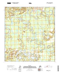
2019 Map of Medfra A-4 SE
USGS Topo · Published 2019About this map
The confluence of major Alaskan waterways dominates this landscape, where the North Fork Kuskokwim River, South Fork Kuskokwim River, and East Fork Kuskokwim River merge into the main stem of the Kuskokwim River. This intricate system of meanders and oxbows, including East Fork Slough and E Fork Slough, reveals a dynamic floodplain where the river constantly reshapes the subarctic terrain. The settlement of Medfra sits along the northern bank, serving as a historic waypoint in this interior region. Smaller tributaries like Medicine Cr and Scow Harry Cr drain the surrounding lowlands, while the tiny settlement of Misdi appears on the eastern edge, illustrating the sparse and river-dependent nature of habitation in the Yukon-Koyukuk Census Area.
Find a feature on this map
16 named features on this map. Tap any name to fly to it.
Don’t see what you’re looking for? This feature index may not catch every label — zoom into the map to look around manually.
Map Details
Editions of this 2019 Medfra A-4 SE Map
This is the sole edition of this map. No revisions or reprints were ever made.
Other maps of this area

1949 · McGrath
USGS Topo · 1:250,000

1950 · Medfra
USGS Topo · 1:250,000

1950 · McGrath
USGS Topo · 1:250,000

1953 · McGrath D-4
USGS Topo · 1:63,360

1954 · McGrath D-3
USGS Topo · 1:63,360

1954 · Medfra A-3
USGS Topo · 1:63,360

1958 · McGrath
USGS Topo · 1:250,000
1959 · Medfra A-4
USGS Topo · 1:63,360

1959 · Medfra
USGS Topo · 1:250,000
2019 · McGrath D-4 NE
USGS Topo · 1:25,000