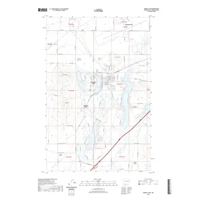
2020 Map of Medical Lake
USGS Topo · Published 2020About this map
Medical Lake and its surrounding waters define this landscape on the eastern edge of the Columbia Plateau, where the city and the institutional grounds of Lakeland Village meet a complex network of wetlands and potholes. The area is characterized by its numerous water bodies, including Silver Lake, West Medical Lake, and Clear Lake, interspersed with prominent basaltic rises like Fancher Butte and Olson Hill. This 2020 record highlights a significant concentration of commemorative and civic sites, notably the Washington State Veterans Cem and Saint Annes Cem. To the northeast, the footprint of Fairchild AFB marks the transition toward the Spokane metropolitan area, while the rural reaches to the west and south, such as Espanola and Malloy Prairie, preserve a pattern of open range and scattered aviation sites like the Flying R Ranch Airport.
Find a feature on this map
108 named features on this map. Tap any name to fly to it.
Don’t see what you’re looking for? This feature index may not catch every label — zoom into the map to look around manually.
Map Details
Editions of this 2020 Medical Lake Map
This is the sole edition of this map. No revisions or reprints were ever made.
Other maps of this area

1943 · Medical Lake
USGS Topo · 1:62,500

1945 · Reardan
USGS Topo · 1:62,500

1953 · Reardan
USGS Topo · 1:62,500

1954 · Airway Heights
USGS Topo · 1:24,000

1954 · Medical Lake
USGS Topo · 1:24,000

1954 · Medical Lake
USGS Topo · 1:62,500

1954 · Cheney
USGS Topo · 1:62,500
1954 · Four Lakes
USGS Topo · 1:24,000

1954 · Sprague
USGS Topo · 1:62,500

1954 · Deep Creek
USGS Topo · 1:24,000