
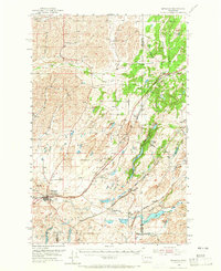
1954 Map of Sprague
USGS Topo · Published 1956About this map
Sprague serves as the primary hub of this 1950s landscape, positioned where the Northern Pacific railroad meets the waters of Negro Creek. The terrain is defined by a dense network of transit and infrastructure, including a Microwave Relay Sta and a Res Landing Strip, reflecting the post-war modernization of eastern Washington. The Channeled Scablands topography is evident in the string of water bodies like Hog Lake, Fishtrap Lake, and Lake Downs, which follow the southwest-trending geological scours.
Find a feature on this map
35 named features on this map. Tap any name to fly to it.
Don’t see what you’re looking for? This feature index may not catch every label — zoom into the map to look around manually.
Map Details
Editions of this 1954 Sprague Map
2 editions found
Other maps of this area

1943 · Medical Lake
USGS Topo · 1:62,500

1945 · Reardan
USGS Topo · 1:62,500

1953 · Reardan
USGS Topo · 1:62,500

1953 · Ritzville
USGS Topo · 1:250,000

1954 · Medical Lake
USGS Topo · 1:24,000

1954 · Medical Lake
USGS Topo · 1:62,500

1954 · Cheney
USGS Topo · 1:62,500

1955 · Spokane
USGS Topo · 1:250,000

1958 · Spokane
USGS Topo · 1:250,000

1959 · Ritzville
USGS Topo · 1:250,000