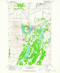
1963 Map of Medical Lake
USGS Topo · Published 1964About this map
Eastern State Hospital and Lakeland Village anchor the landscape of this mid-century survey, defining the eastern shore of West Medical Lake. The town of Medical Lake sits at the center of a complex network of freshwater bodies, including Silver Lake and Clear Lake, which shape the local geography alongside basaltic landforms like Fancher Butte. This era shows a significant intersection of healthcare infrastructure and defense, as the vast grounds of Fairchild Air Force Base occupy the northern portion of the sheet. Transportation is dominated by the competing corridors of the Great Northern and Northern Pacific railroads, which cross the terrain to serve settlements like Espanola. Notable for genealogists are the well-defined boundaries of the Medical Lake Cemetery and St Annes Cemetery, providing clear spatial context for local family history research.
Find a feature on this map
49 named features on this map. Tap any name to fly to it.
Don’t see what you’re looking for? This feature index may not catch every label — zoom into the map to look around manually.
Map Details
Editions of this 1963 Medical Lake Map
This is the sole edition of this map. No revisions or reprints were ever made.
Other maps of this area

1943 · Medical Lake
USGS Topo · 1:62,500

1945 · Reardan
USGS Topo · 1:62,500

1953 · Reardan
USGS Topo · 1:62,500

1954 · Airway Heights
USGS Topo · 1:24,000

1954 · Medical Lake
USGS Topo · 1:24,000

1954 · Medical Lake
USGS Topo · 1:62,500

1954 · Cheney
USGS Topo · 1:62,500
1954 · Four Lakes
USGS Topo · 1:24,000

1954 · Sprague
USGS Topo · 1:62,500

1954 · Deep Creek
USGS Topo · 1:24,000