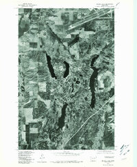
1978 Map of Medical Lake
USGS Topo · Published 1981About this map
Medical Lake and the surrounding plateau of Spokane County are captured in this late-1970s orthophotomap, revealing the distinct relationship between the town and the basalt-rimmed depressions that form the region's lakes. The satellite-style imagery emphasizes the unique geology of the Channeled Scablands, where the elongated shapes of Silver Lake and Clear Lake reflect the erosive power of ancient floodwaters. This specific format highlights the transition from concentrated urban development to the surrounding agricultural fields and the high ground of Olson Hill and Booth Hill. Researchers can observe the mid-century infrastructure and land-use patterns, including the airfield to the north and the complex network of roads that connect these isolated water bodies to the growing town center.
Find a feature on this map
5 named features on this map. Tap any name to fly to it.
Don’t see what you’re looking for? This feature index may not catch every label — zoom into the map to look around manually.
Map Details
Editions of this 1978 Medical Lake Map
This is the sole edition of this map. No revisions or reprints were ever made.
Other maps of this area

1943 · Medical Lake
USGS Topo · 1:62,500

1945 · Reardan
USGS Topo · 1:62,500

1953 · Reardan
USGS Topo · 1:62,500

1954 · Airway Heights
USGS Topo · 1:24,000

1954 · Medical Lake
USGS Topo · 1:24,000

1954 · Medical Lake
USGS Topo · 1:62,500

1954 · Cheney
USGS Topo · 1:62,500
1954 · Four Lakes
USGS Topo · 1:24,000

1954 · Sprague
USGS Topo · 1:62,500

1954 · Deep Creek
USGS Topo · 1:24,000