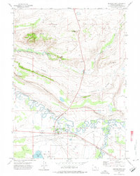
1971 Map of Medicine Bow
USGS Topo · Published 1975About this map
Medicine Bow anchors this Carbon County landscape, situated at the junction of the Union Pacific railroad and the Medicine Bow River. The town is depicted with its core infrastructure, including an Airport, Athletic Field, and nearby Cem alongside the Vandiver ditch system. The topography is defined by prominent east-west uplift features such as Slate Ridge and Fossil Ridge, which hem in the meandering river valleys. Outside the main settlement, the map traces a rural economy of isolated outposts like Two Bit Ranch and the evocative Robbers Roost Ranch near Rock Creek. An Old Railroad Grade and an Aqueduct crossing the prairie suggest evolving patterns of transport and water management in this high-plains environment, while East Allen Lake and several scattered Oil Wells highlight the region's natural resources.
Find a feature on this map
37 named features on this map. Tap any name to fly to it.
Don’t see what you’re looking for? This feature index may not catch every label — zoom into the map to look around manually.
Map Details
Editions of this 1971 Medicine Bow Map
2 editions found
Other maps of this area

1914 · Saddleback Hills
USGS Topo · 1:62,500

1915 · Como Ridge
USGS Topo · 1:48,000

1918 · Como Ridge
USGS Topo · 1:62,500

1921 · Saddleback Hills
USGS Topo · 1:62,500

1954 · Rawlins
USGS Topo · 1:250,000

1955 · Casper
USGS Topo · 1:250,000

1958 · Rawlins
USGS Topo · 1:250,000

1958 · Casper
USGS Topo · 1:250,000
1961 · Walker Draw SE
USGS Topo · 1:24,000

1961 · T B Ranch
USGS Topo · 1:24,000