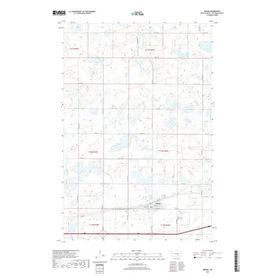
2017 Map of Medina
USGS Topo · Published 2017About this map
Medina serves as the focal point of this North Dakota landscape, situated along the southern edge of a glaciated prairie region characterized by a high density of wetlands and small kettle lakes. The settlement is organized around a grid of streets including NP St Nw and NP St Ne, which parallel the major transportation corridor traversing the southern portion of the quadrangle. Local infrastructure and community markers are evident in the layout of School St E and the nearby Saint Marys Cem, located just southeast of the main town site. Beyond the town limits, the landscape transitions into a methodical section-line grid defined by routes like Co Rd 39 and 36th St SE. These roads divide the townships of t140n r68w and t139n r68w, illustrating the enduring influence of the Public Land Survey System on the agricultural and transit patterns of Stutsman County.
Find a feature on this map
23 named features on this map. Tap any name to fly to it.
Don’t see what you’re looking for? This feature index may not catch every label — zoom into the map to look around manually.
Map Details
Editions of this 2017 Medina Map
This is the sole edition of this map. No revisions or reprints were ever made.
Other maps of this area

1952 · New Rockford
USGS Topo · 1:250,000

1953 · Jamestown
USGS Topo · 1:250,000

1953 · Cleveland SW
USGS Topo · 1:24,000

1954 · Cleveland NW
USGS Topo · 1:24,000

1954 · Medina
USGS Topo · 1:24,000

1955 · Crystal Springs
USGS Topo · 1:24,000

1955 · Medina SW
USGS Topo · 1:24,000

1955 · Medina SE
USGS Topo · 1:24,000

1956 · New Rockford
USGS Topo · 1:250,000

1956 · Jamestown
USGS Topo · 1:250,000