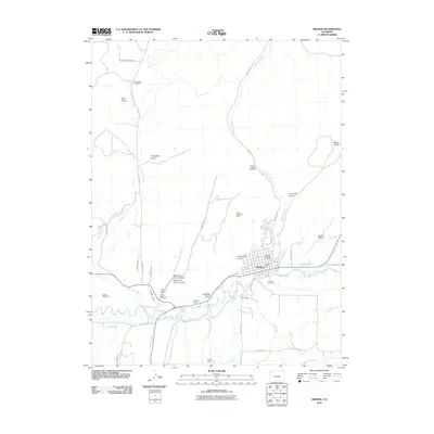
2010 Map of Meeker
USGS Topo · Published 2010About this map
Meeker serves as the focal point of this Northwest Colorado landscape, where the valley of the White River meets an extensive network of irrigation and mining operations. The map documents a significant industrial and water-management footprint, with features like the Meeker Ditch, Powell Park Ditch, and Pease Ditch drawing from the river to support the surrounding gulches. The area's extraction history is visible through numerous named operations, including the North Meeker Coal Mine, Black Diamond Mine, and the Northern Number One Mine. Cultural landmarks provide deep historical context, most notably the site of the Meeker Massacre, while the Strawberry Cemetery and Highland Cemetery offer essential data points for local genealogy. The complex terrain is carved by seasonal drainages such as Strawberry Creek, Sulphur Creek, and Flag Creek, creating a distinct pattern of settlement concentrated near the municipal center and the Meeker Airport.
Find a feature on this map
47 named features on this map. Tap any name to fly to it.
Don’t see what you’re looking for? This feature index may not catch every label — zoom into the map to look around manually.
Map Details
Editions of this 2010 Meeker Map
This is the sole edition of this map. No revisions or reprints were ever made.
Other maps of this area

1906 · Grand Hogback
USGS Topo · 1:125,000

1907 · White River
USGS Topo · 1:125,000

1910 · Danforth Hills
USGS Topo · 1:125,000

1910 · Grand Hogback
USGS Topo · 1:125,000

1910 · White River
USGS Topo · 1:125,000

1912 · Meeker
USGS Topo · 1:62,500

1914 · Meeker
USGS Topo · 1:62,500

1952 · Segar Mountain
USGS Topo · 1:24,000

1954 · Vernal
USGS Topo · 1:250,000

1954 · Craig
USGS Topo · 1:250,000