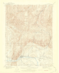
1912 Map of Meeker
USGS Topo · Published 1958About this map
The White River flows through the heart of this 1912 survey, anchoring the settlement of Meeker and the nearby Agency site. At this time, the valley is a patchwork of early homesteading and ranching activity, with numerous family-named holdings like the Valentine Ranch, Goff Ranch, and Miller Ranch dotting the landscape. The distribution of Powell Park School, Mesa School, and Coal Creek School indicates a well-established rural community structure in the early 20th century.
Find a feature on this map
46 named features on this map. Tap any name to fly to it.
Don’t see what you’re looking for? This feature index may not catch every label — zoom into the map to look around manually.
Map Details
Editions of this 1912 Meeker Map
2 editions found
Other maps of this area

1906 · Grand Hogback
USGS Topo · 1:125,000

1907 · White River
USGS Topo · 1:125,000

1910 · Danforth Hills
USGS Topo · 1:125,000

1910 · Grand Hogback
USGS Topo · 1:125,000

1910 · White River
USGS Topo · 1:125,000

1912 · Meeker
USGS Topo · 1:62,500

1912 · Axial
USGS Topo · 1:62,500

1914 · Meeker
USGS Topo · 1:62,500

1914 · Axial
USGS Topo · 1:62,500

1915 · Monument Butte
USGS Topo · 1:62,500