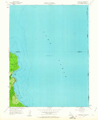
1955 Map of Meeks Bay
USGS Topo · Published 1963About this map
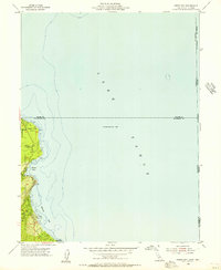
Lake Tahoe dominates this mid-century survey, its deep waters reaching a maximum elevation of 6,229 feet along the western shoreline of El Dorado and Placer counties. The narrow strip of developed land between the water and the rising slopes of the Eldorado National Forest is anchored by the community of Tahoma, which appears here as a growing residential grid. Detailed bathymetric contours reveal the underwater shelf and sudden drop-offs of the lake, particularly near the mouth of Meeks Bay, while the shoreline is marked by prominent landmarks like Sugar Pine Point. This map provides a clear record of the early recreational development and land management boundaries before the significant expansion of the late 20th century.
Find a feature on this map
2 named features on this map. Tap any name to fly to it.
Don’t see what you’re looking for? This feature index may not catch every label — zoom into the map to look around manually.
Map Details
Editions of this 1955 Meeks Bay Map
3 editions found

Other maps of this area

1889 · Pyramid Peak
USGS Topo · 1:125,000

1889 · Markleeville
USGS Topo · 1:125,000

1891 · Carson
USGS Topo · 1:125,000

1891 · Markleeville
USGS Topo · 1:125,000

1891 · Truckee
USGS Topo · 1:125,000

1891 · Pyramid Peak
USGS Topo · 1:125,000

1893 · Carson
USGS Topo · 1:125,000

1893 · Markleeville
USGS Topo · 1:125,000

1893 · Truckee
USGS Topo · 1:125,000

1895 · Pyramid Peak
USGS Topo · 1:125,000