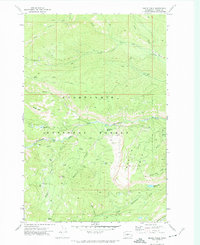
1971 Map of Meeks Table
USGS Topo · Published 1974About this map
Snoqualmie National Forest dominates this 1971 landscape, a high-country terrain defined by prominent flat-topped landmarks and a dense network of watercourses. The prominent namesake, Meeks Table, sits in the west, while its counterpart, Devils Table, rises to the east above the deep cut of Devils Canyon. The drainage pattern is complex, with Nile Creek and its branches flowing east toward the Naches River valley, and Rattlesnake Creek carving through the center of the sheet. Isolated mountain waters like McDaniel Lake, Angel Lake, and Boundary Lake dot the higher elevations near Bethel Ridge. These features indicate a landscape managed for wilderness and forestry, accessible primarily by a system of Pack Trails and primitive Jeep Trails that traverse Cowpuncher Ridge and the surrounding peaks.
Find a feature on this map
35 named features on this map. Tap any name to fly to it.
Don’t see what you’re looking for? This feature index may not catch every label — zoom into the map to look around manually.
Map Details
Editions of this 1971 Meeks Table Map
2 editions found
Other maps of this area

1899 · Ellensburg
USGS Topo · 1:125,000

1901 · Ellensburg
USGS Topo · 1:125,000

1902 · Mount Aix
USGS Topo · 1:125,000

1904 · Mt Aix
USGS Topo · 1:125,000

1950 · Yakima
USGS Topo · 1:250,000

1958 · Yakima
USGS Topo · 1:250,000

1961 · Yakima
USGS Topo · 1:250,000

1967 · Rimrock Lake
USGS Topo · 1:24,000

1967 · Tieton Basin
USGS Topo · 1:24,000

1971 · Nile
USGS Topo · 1:24,000