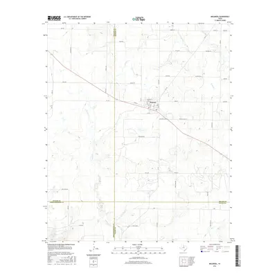
2016 Map of Megargel
USGS Topo · Published 2016About this map
Megargel serves as the central hub of this North Texas landscape, where the agricultural grid is defined by a dense network of country roads and seasonal waterways. The town site itself is meticulously detailed, showing the layout of streets from 1st Ave to St Marys St, alongside the convergence of FM 210 and FM 1285. This area, situated at the junction of Archer, Baylor, Throckmorton, and Young counties, is characterized by a sprawling network of creeks including Spring Creek, Kickapoo Creek, and Bitter Creek. Many of the rural routes, such as Symank Road, Matus Road, and Harmel Road, appear to be named for local families, providing significant value for those tracing regional land use and lineage in this part of the state.
Find a feature on this map
55 named features on this map. Tap any name to fly to it.
Don’t see what you’re looking for? This feature index may not catch every label — zoom into the map to look around manually.
Map Details
Editions of this 2016 Megargel Map
This is the sole edition of this map. No revisions or reprints were ever made.
Other maps of this area

1932 · Dundee
USGS Topo · 1:62,500

1954 · Wichita Falls
USGS Topo · 1:250,000

1958 · Wichita Falls
USGS Topo · 1:250,000

1963 · Dundee SW
USGS Topo · 1:24,000

1963 · Megargel
USGS Topo · 1:24,000

1964 · Padgett
USGS Topo · 1:24,000

1964 · Dundee SE
USGS Topo · 1:24,000
1964 · Lake Olney
USGS Topo · 1:24,000

1964 · Olney
USGS Topo · 1:24,000

1966 · Westover SE
USGS Topo · 1:24,000