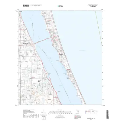
2021 Map of Melbourne East
USGS Topo · Published 2021About this map
The Atlantic coast of Brevard County is defined by the narrow barrier islands and the expansive waters of the Indian River Lagoon. In the city of Melbourne, the urban layout converges at the Melbourne Causeway, a vital link crossing the Indian River to the coastal communities of Indialantic and Melbourne Beach. Further south, the sprawl of Palm Bay is punctuated by the winding course of Turkey Creek and the man-made Melbourne-Tillman Canal, reflecting a landscape heavily modified for drainage and residential expansion. On the mainland, the Florida Institute of Technology serves as a prominent landmark. Along the coastline, various geographic points such as Cape Malabar, Castaway Point, and Coconut Point mark the transition between the lagoon and the open Atlantic Ocean, while the Malabar Scrub Sanctuary preserves a remnant of the native Florida scrub environment.
Find a feature on this map
35 named features on this map. Tap any name to fly to it.
Don’t see what you’re looking for? This feature index may not catch every label — zoom into the map to look around manually.
Map Details
Editions of this 2021 Melbourne East Map
This is the sole edition of this map. No revisions or reprints were ever made.
Other maps of this area

1949 · Melbourne West
USGS Topo · 1:24,000

1949 · Melbourne East
USGS Topo · 1:24,000

1949 · Sebastian NW
USGS Topo · 1:24,000

1949 · Eau Gallie
USGS Topo · 1:24,000

1949 · Grant
USGS Topo · 1:24,000

1949 · Tropic
USGS Topo · 1:24,000

1951 · Sebastian NW
USGS Topo · 1:24,000

1951 · Melbourne East
USGS Topo · 1:24,000

1951 · Eau Gallie
USGS Topo · 1:24,000

1951 · Melbourne West
USGS Topo · 1:24,000