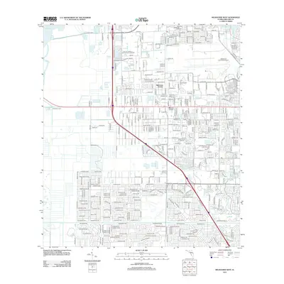
2012 Map of Melbourne West
USGS Topo · Published 2012About this map
Saint Johns River and Lake Washington define the western margin of this landscape, where the marshy edges of the river basin meet the expanding suburban footprint of Florida's Space Coast. The transition from the wetlands of Sweetwater Camp to the dense street grids of Melbourne Gardens and Mintons Corner illustrates the rapid post-war development of the region. This 2012 survey captures the intricate network of residential streets and drainage canals that replaced earlier agricultural or wild lands. The presence of Melbourne International Airport at the northeast corner signals the area's importance as an aviation and industrial hub, while watercourses like the Eau Gallie River and Elbow Cr continue to serve as primary natural drainage features for the inland neighborhoods.
Find a feature on this map
377 named features on this map. Tap any name to fly to it.
Don’t see what you’re looking for? This feature index may not catch every label — zoom into the map to look around manually.
Map Details
Editions of this 2012 Melbourne West Map
This is the sole edition of this map. No revisions or reprints were ever made.
Other maps of this area

1949 · Melbourne West
USGS Topo · 1:24,000

1949 · Melbourne East
USGS Topo · 1:24,000

1949 · Eau Gallie
USGS Topo · 1:24,000

1949 · Grant
USGS Topo · 1:24,000

1949 · Tropic
USGS Topo · 1:24,000

1951 · Melbourne East
USGS Topo · 1:24,000

1951 · Eau Gallie
USGS Topo · 1:24,000

1951 · Melbourne West
USGS Topo · 1:24,000

1951 · Grant
USGS Topo · 1:24,000
1951 · Tropic
USGS Topo · 1:24,000