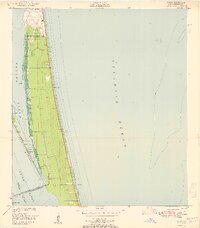
1951 Map of Tropic
USGS Topo · Published 1951About this map
Merritt Island sits between the Banana River and the Indian River in this mid-century survey of coastal Florida. This narrow barrier landscape shows the transition from the settlement at Eau Gallie and the small coastal hub of Tropic to a large northern U S Military Reservation that dominates the upper end of the peninsula. The map captures a moment before the massive industrialization of the space race, when the area was defined by its water access and low-density coastal development.
Find a feature on this map
17 named features on this map. Tap any name to fly to it.
Don’t see what you’re looking for? This feature index may not catch every label — zoom into the map to look around manually.
Map Details
Editions of this 1951 Tropic Map
This is the sole edition of this map. No revisions or reprints were ever made.
Other maps of this area

1949 · Melbourne West
USGS Topo · 1:24,000

1949 · Melbourne East
USGS Topo · 1:24,000

1949 · Eau Gallie
USGS Topo · 1:24,000

1949 · Cocoa
USGS Topo · 1:24,000

1949 · Cocoa Beach
USGS Topo · 1:24,000

1949 · Tropic
USGS Topo · 1:24,000

1951 · Melbourne East
USGS Topo · 1:24,000

1951 · Eau Gallie
USGS Topo · 1:24,000

1951 · Cocoa
USGS Topo · 1:24,000

1951 · Melbourne West
USGS Topo · 1:24,000